Fogou – what are they?

In Cornwall they are known as Fogou, meaning in the Cornish language, Caves. (In Cornwall alone it is estimated there are over 2,000 fogous). In Scotland as Earth houses, though they are more usually called Souterrains (from the French, under the ground). Widely found across Britain, Ireland and Europe. Some can be quite complex tunnels, but usually they consist of an underground passage or tunnel with a narrow opening at the far end to just let a small amount of light through, but certainly not wide enough to exit through.

So what purpose did they serve? No one knows, we can only speculate. Places of refuge, of storage, or ritual shrines?

Above are two photographs of a Souterrain visited in Scotland on the Isle of Skye. In photograph 1 you might just distinguish a pair of wellies, (yellow, top right), put there to indicate that this particular souterrain was flooded.  Which added considerably to the atmosphere as I and my companion went down and into it.  As with most souterrains, the floor sloped upwards toward the end of the passage providing a little space to sit above the water for one of us at least.

And as for the question asked at the beginning? I am no wiser, but it didn’t feel as though this particular passage would serve any purpose as a storage means, especially given the effort taken to construct it. A place of refuge. Too low, too narrow too cramped to hide for long from attackers. A place with a ritual purpose? For some kind of initiation process perhaps? Sat in the gloom of a Neolithic construction some 2-3,000 years old with the water lapping about, most certainly!

A thin place

DSC01299

What is a thin place? It’s a location where the gap between this world and the spiritual one is at its thinness. In my experience,  Dale Abbey is such a place. Not the Abbey itself, forlorn, forgotten ruin that it now is, but the cave nearby. Legend has it that in the 12th century there was a baker living in nearby Derby who was a very holy man. He decided to give up his livelihood, and become a hermit. He travelled to the village and made his home in a cave which today remains in good condition as the photograph shows.

His reputation spread, to such an extent it is said that the Abbey was founded to be close to this holy man.  The cave/hermitage is easily accessed though the path up to it is steep in places. Inside the cross carved by the hermit is clearly visible, and the sounds of the outside world die away.  I stopped there for several minutes, and said a prayer in the stillness, easily imaging the presence of that holy man.

As I left, the stillness of the day was broken by a small gust of wind that came and went, stirring the leaves at my feet, as though to say , “Welcome friend, may God be with you.” It was  special moment in a special place, a thin place indeed.

Maeshowe tomb – with a door that can only be sealed from inside it?

Maeshowe is an exquisite feat achieved by a group of builders who lived and worked some 5,000 years ago on Orkney.  The mound is 35 meters in diameter, 7 metres high inside, and despite the passage of five millennia, warm and dry within. Running off the main chamber are three cells that it appears can be sealed with stone slabs which now lie on the floor.  There is also a blocking stone at the entry  to the entry passage which seems to be designed so that it can only be closed from the inside. And at each Winter solstice, the rising sun shines directly into the tomb, rising in the fold of the hills of the island of Hoy opposite, and shining directly over the Barnhouse standing stone located several hundred meters away.

But is it a tomb? Variously described as a Chamber Cairn and a passage grave, the fact is that when it was excavated 1861 there was only one skull to be found inside, although it was also clear that it had also been used by the Vikings to shelter from inclement weather, and as a result, has the largest single collection of Runes in the world. But that is another story.

It seems unlikely to have been a tomb only, or at all perhaps, but for what other purpose would the people of the Orkneys put up to 100,000 man hours of work and transported stones weighing up to 30 tons? We shall never know, we can only speculate.

The site www.maeshowe.co.uk shows photographs of past winter solstices shot from inside the tomb as well as some spectacular shots taken of the interior.


A Neolithic sauna – or a sweat lodge?


sauna
A “Burnt Mound” near to the Tomb of the Eagles in Orkney.

I had never seen one before, or even read about them. Yet when I did some research on the web, I discovered that over 300 had been discovered around and in Birmingham alone. Apparently they are quite common place.

What are they? They are called “Burnt Mounds” and they consist broadly of a mound of shattered stones with a nearby trough. The latter is always water-tight, and the one in the photograph can be clearly seen. They date back thousands of years, to the Neolithic and perhaps beyond, and there is even evidence that they were used as late as the 14th century AD.

But for what purpose? Some theories suggest cooking.  The stones would have been heated up in fires, and then dropped into the water to heat it for cooking meat. The flaw in this argument is that no evidence for cooking has ever been found in the many locations where they have been used. No bones, no remains from the preparation of meat.

A better explanation that seems to fit the facts is that they were saunas.  It is easy to picture a group of hunter-gatherers warming up the water with the heated rocks, and after a hard days food gathering, relaxing, for a moment out of the wind, the rain and the elements. Apparently in some locations signs of post-holes have been found, so perhaps some of these “Burnt Mounds” were covered to keep the heat and the steam inside. A Neolithic sweat lodge maybe?

I rather like to think so.

The Tower of the Winds

What a wonderful title for a tower, and no, it’s not found in the Lord of the Rings trilogy. Instead it stands inside the Vatican and was built to answer, in effect, the question, how long is a day. The answer that they came up with was not 24 hours, but rather 23 hours and fifty six minutes.
The Tower of the Winds was built between 1578 and 1580 as a means leading to the reform of the Julian calendar which had been in use since 45 BCE. At midday the sun shines through a hole in the wall, and illuminates a large sundial inscribed on the floor of the tower, and thus provided the means of calculating the true length of a day.

towerofwinds

The Gregorian calendar that followed introduced the leap year as a means of compensating for the real length of a day.
As the photo shows, the Tower is richly decorated, and is one of the highest points in Vatican City.
But predating that is an even older Tower of the Winds, to be found in Athens. I can do no better than quote from the Athens Tourist Information web site, viz:

Torre_dels_Vents_d'Atenes

The Tower of the Winds is found in the Roman Agora of Athens, between the quarters of Plaka and Monastiraki. This is among the most famous sights of Athens. A 12-metre-tall structure with a diameter of 8 metres, this tower has octagonal shape. It was made of fine Pentelic marble probably around 50 B.C. by the Greek astronomer Andronicus of Cyrrhus. This tower has many uses in the ancient times. It was originally constructed as a time piece, that is to estimate time, based on the position of the sun. It was also used for weather indicating and forecasting. The tower features a combination of sundials, a water clock and a wind vane. In fact, its frieze depicts the eight wind deities according to their direction: Boreas (N), Kaikias (NE), Eurus (E), Apeliotes (SE), Notus (S), Livas (SW), Zephyrus and Skiron (NW). Source: http://www.greeka.com

Glastonbury

IMGP5647
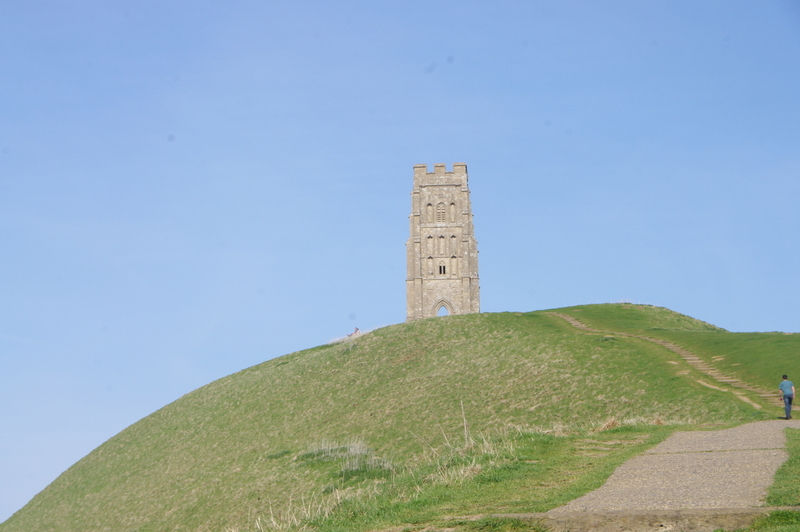
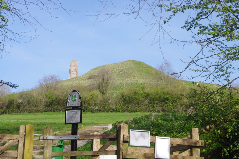
Otherwise known as the Isle of Avalon. A strange, mysterious place, even now the smell of incense pervades the air and mostly defeats the traffic fumes. Once upon a time it really was an Island, secured by the surrounding bogs and water courses that surrounded it. But gradually the bogs were drained for agricultural purposes and the Island became just another part of the landscape, albeit topped with a most unusual hill, known as Glastonbury Tor.

IMGP5666

This in turn is topped by a medieval tower that adds to the striking profile of the Tor. Legend has it that beneath the Tor exists the realm of Gwyn ap Nudd, the king of the Tylwyth Teg or “fair folk” and ruler of the Celtic (especially Welsh) Otherworld. Another tradition portrays him as the leader of the Wild Hunt, in which he leads a pack of supernatural hounds known as the Cŵn Annwn to harvest human souls. In Welsh folklore, to hear the baying of Gwyn’s hounds was a portent of imminent death in the family.

And there is much more to Glastonbury. A place where seventy differnt faiths are practised, a place of piligrimage that dates back two millenia, of sacred springs, and a high street that offers some of the most unique products, from gongs to healing, from spells to tarot readings.

A mix of photos of the Chalice Well and the stream that runs from it, together with photographs of a shop on the main street and an arcade.

Julian’s Bower

Version 2

Julian’s Bower is a turf maze found in Alkborough in North Lincolnshire. Unusually there is a carving of the maze in the stone floor of the porch of the nearby church. (There is also a copy on the East window of the church, and on a gravestone in the nearby cemetery).
As the photo just shows, the view from the maze is stunning, and on a fine day reveals the countryside for many miles around. But why a maze, and what purpose did they serve?
The idea of the maze goes back as far as the legend of Theseus and the Minotaur. Theseus, son of King Aegeus of Athens. He used a ball of wool given to him by Ariadne to mark his way through the labyrinth of the Minotaur in Crete, where he slayed the monster and retraced his steps with the aid of the thread and so to safety.
Perhaps the best theory is that this maze was carved by a small cell of monks who lived in the area until the 13th century, and that it represents the path through life to heaven. This would fit in with the carving in the porch of the church.
It is also thought that mazes were also used for penitential purposes, so sinners would be made to trace the path upon their hands and knees. Yet another theory is that mazes were a way to confound the Devil, who could only travel in straight lines.
Turf mazes are all unicursal, that is, they have no choices or branches, and there are a number still to be found across England. The dates for their creation are all guesses, since because they are turf, they have to be renewed frequently, or they disappear, as many presumably have.

The Rudston Monolith

OLYMPUS DIGITAL CAMERA

It is both surprising and stunning. As you come around the edge of Rudston church, there is the monolith, the tallest in England at 7.6 metres, with reputedly the same length buried under the ground.. It is so unexpected that the stranger can only stop and admire. Of course it predates the church by many thousands of years, and it’s presence says something very clearly.

This is a holy site, and has been for millennia. It is one of many henges, standing stones, circles and tumulus that still litter the landscape, that speak of a past now lost to us. Their silent witness tells of people who cared enough to put huge effort into constructing and erecting monoliths such as this one. But why? We can only speculate. Speculate not only about the purpose, though that is grand enough. But who organised the fetching of the stone that forms it? Who fed the labourers, who had the knowledge and skill to erect a structure that has lasted thousands of years? They clearly had the leadership, resources and commitment not out of place in a modern company. Reflect on the fact that the monolith weights some 26 tons, and was transported a distance of 10 miles to its present site, and ask yourself the question, how far have we really progressed today?

510 years ago a tradition was born

P1020484

It begins at 4.00 am when a flute band plays outside the houses of two of the main participants in the Selkirk Common Riding, a tradition that dates back to the Battle of Floden in 1508. Of the 80 men who left Selkirk to fight for the cause of James IV of Scotland, only one, Fletcher, returned.

Selkirk Standard Bearer setting off on the Common Riding of 2018, accompanied by 300 other riders
But he came back bearing a captured English banner, and that is at the heart of the event. Some 300 riders parade through the town, and most importantly the Standard Bearer and his attendants are at the heart of the event.
The pride of the community in their annual event is tangible, and if that isn’t enough to touch the heart of an onlooker, the sound of the bands will succeed, especially from the bagpipes of the Pipe Band.

A face that still haunts me

We were staying at Avebury for a week or so and soon after arriving I went exploring. Away from the stones that dominate the landscape and toward Silbury Hill, another man-made feature that dominates in a very different way. The ground became boggy, due to the effect of a small spring of water, overlooked by a few straggly trees.

cadbury-hill
Silbury Hill in Wiltshire, one of the largest prehistoric manmade mounds in the world

The water that flowed out of the ground didn’t even warrant the title “stream”, trickle was a more apt description for the small outflow of water running over a few rocks and surrounded by a mantle of mud. I trod warily, trying to avoid the soft, sticky mire, distracted also by the number of items hanging from the trees surrounding the water. I found myself constantly looking up into their branches, which were hung with a panoply of teddy bears, ribbons of all descriptions, and a host of small trinkets and mirrors that glittered as they spun in the breeze and caught the sunlight

Treegiftstouched
Gifts and request for healing adorn the trees.

And then – an unexpected discovery as I looked down instead of up. There at the source of the spring, was a face. It stopped me in my tracks, and for a moment I wondered if I was really alone, the face seemed to have been so recently created. As I looked harder, I saw the two green leaves that represented tears, and felt the pain that seemed to emanate from it. I wondered who had created it, and what it meant to them, and I hoped that it represented a turning point, a transition that led to light and love. I stood there for a long time, feeling the mystery of the face, wondering about it’s creator, caught also by the ancient spirit of my surroundings, a place that felt outside of time. Of my time anyway.

DSC02474
The Face – saying what?

I returned to that place a few times during the week that I spent holidaying nearby. I learnt that it was a place of healing, with a history that went back thousands of years, before Roman feet walked the land, and that somehow, the knowledge of its power had not been lost, and some still visited it.
On my visits, I never did see anyone else at this sacred site, although there was always a feeling, a feeling of awareness of a – I have no word for it – a presence.

A thin place – where this world touches the other?


Design a site like this with WordPress.com
Get started